Gyðjan - 100 km
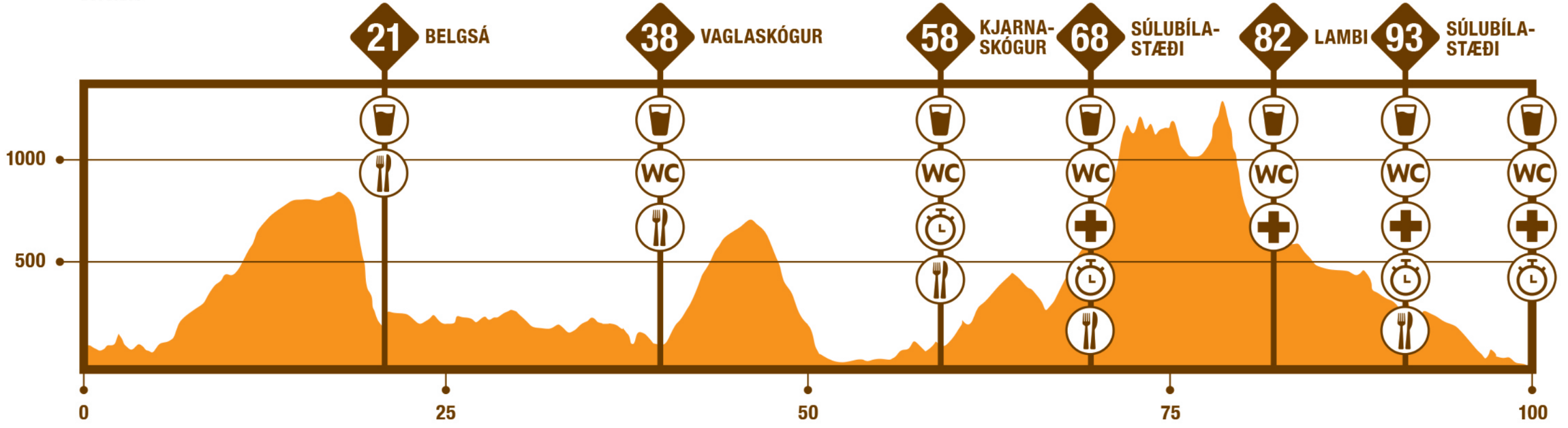
Gyðjan is a 100 km trail race with an ascent of 3580 m. The race starts at the spectacular and historic waterfall Godafoss. From there you´ll run across Belgsárfjall mountain and Vadlaheiði heath towards Akureyri, to the top of Súlur mountain, into Glerárdalur valley and from there into the center of Akureyri town.
The race starts at a beautiful vantage point by Godafoss at an altitude of about 110 m above sea level.
Head west across Skjálfandafljót on a footbridge and along Ring road no. 1, across a bridge at Hrúteyjarkvísl. Then turn south onto Bárðardalsvegur west and follow the trail through a 9000 year old lava field. Turn west onto the driveway to Öxará towards the first accend. You´ll run roughly 4 km through mud and peat to a ford in Öxará at an altitude of 430 m. Wading is easy, the depth is only mid-calf.
From there you head west for 7,5 km to the cairn at the top of Belgsárfjall at an altitude of 830 m. This path is rocky in parts and you have to be careful. From the man-made stone guard you head southwest to the edge of the mountain (remember to enjoy the view over the valley!), after which you start a 650 m descent down the mountain ridge to the deserted farm Belgsá, where you will reach the first check point at 21 km.
From Belgsá, run north along a small gravel road to the bridge at Illugastaðir. Do NOT run over the bridge, but continue east of the river and run north through Þórðarstaðskógur, the summerhouse district in Lundskógur and on forest trail through Vaglaskógur to the second check point at 37 km. It should be noted that Vaglaskógur is one of the largest natural birch forests in the country, along with Hallormsstaðaskóð.
From Vaglaskógur, you run west over the old arch bridge at Fnjóská, which was built in 1908. It is 55 meters long and was for a long time the longest stone arch bridge in the Nordic countries. It is also considered by many to be among the most beautiful structures built in Iceland in the 20th century. From the bridge, run up to the main road and follow it to the south, almost 3 km to Systragil. Make sure to run on the left side against the traffic and be careful.
At Systragil, turn right onto Þingmannaleið, which was the main transport route between Þingeyjarsýsla and Eyjafjörður throughout the centuries. Head towards the second mountain number where you´ll accend 580 m in the next 7 km towards the top of Vaðlaheiði (680 m). Up on the heath there is a remarkable rock structure from the year 1871. Then the path starts to go downhill and there is a 660 m descent on a nice trail towards the road north of Eyrarland.
Run along the road for roughly 500 m onto a path along the main road for 1,5 km. Cross over Eyjafjarðarbraut east (carefully!) and run along a dirt road over the old bridges on Eyjafjarðará. This road used to be the main road to Akureyri from the east. You´ll enter a protected area with a lot of birdlife.
Next you´ll cross Eyjafjarðarbraut west on a pedestrian crossing (carefully!) and up to Kjarnaskógur where you´ll find the next check point (58km) and your drop bag. At this check point, assistants are allowed.
From Kjarnskógur, you can climb up to top of the rocks sitting above the forest where you´ll have a good view of Akureyri town and the fjord. After ca. 300 m of ascent, you pass Gamli, an old scout lodge and onwards past the second scout lodge called Fálkafell. A short decend will take you towards Súlur parking lot for the next check point at 68 km.
After the check point you´ll start a 900 m ascend to the top of Súlur mountain. At the top, you´ll continue Syðri Súlur and then south along the mountain range, past Krummi and Litli Krummi, then turn down into Lambárdalur, over Lambárjökull and up to Lambáröxl. After a steep decend into Glerárdalur valley, you´ll reach the next check point at Lambi hiking lodge (82 km) which is run by the local search and rescue team. This part of the route is rocky and steep in parts, and we recommend that you proceed with caution.
From Lambi, a 11 km trail leads you back to Sulur parking lot for the 6th and final check point at 93 km. The path from there crosses a small canyon and then follows the path along the river Glerá. Cross Hlíðarbraut (road) and continue along Glerá to the University of Akureyri. The race finishes with a 2-3 km run along the streets of Akureyri into the center of town.
Competitors in Gyðjan must have a track of the route in a watch or phone.
Start times
- Start times will be announced later.
Time limits
- Runners need be able to complete the race in 22 hours.
More information about time limits along the way will be published later. - Those runners who do not reach this time limit must stop the race. This policy applies to all participants and cannot be negotiated with race officials during or before the race.
Price
Registration deadline: 01.07.2024, 23:59
- 26,250 ISK (Price until 31.01.2024 23:59)
- 29,750 ISK (Price until 01.06.2024 23:59)
- 35,000 ISK (Full price)
Mandatory equipment
- Bottle/glass 0.5 l minimum (there will be no glasses at drinking stations)
- A phone with enough charge and the emergency number 112 saved together with the race manager's phone number: 822 4115
- Aluminum blanket with a minimum size of 130 x 200 cm
- Headlight
- Whistle
- A jacket
- Buff/hat
- Gloves
- Elastic band/tape (100 x 5 cm)
- Energy corresponding to a minimum of 800 kcal when setting off
The following may be added as related equipment if the weather forecast is bad, will be issued two days before the race
- High socks/calf guards or trousers
- Extra sweater
- Waterproof gloves
- Waterproof jacket
Poles: You are allowed to run with poles, but the rule is that if you start the race with poles, you must end the race with poles.
During the race, participants must wear the mandatory equipment. Race officals may request an equipment check before, during and after the race.
If mandatory equipment is missing, there is a time penalty (15–60 minutes added to the person's final time, depending on how much mandatory equipment is missing). A participant can be dismissed from the competition if a lot of mandatory equipment is missing.
Check points
- Belgsá after 21 km: Water and nutrition
- Vaglaskógur after 38 km: Water and nutrition
- Kjarnaskógur after 58 km: Water and nutrition
- Súlur parking lot 68 km: Water and food
- Lambi after 82 km: Water and nutrition
- Súlur parking lot after 93 km: Water and refreshments
- Fallorkustígur after 95,5 km: Water, self-service